


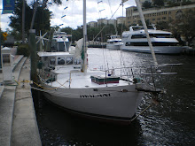
IwalaniCurrent position Saturday 03-21-09, Lat: 25* 4.5 N, Long: 077* 18.7 WNassau, Bahama; Nassau Harbour Club slip #10Winds ENE 25-30 kts; mostly clear skies, good visibility.
Thursday 03-12-09, Lat: 26* 17.4N, Long: 079* 57.7W1320: Depart Fort Lauderdale (finally!) towards West End, Grand Bahama Island. COG (course over ground) 077* (refer to 360* compass, 077* is a ENE direction). Open ocean crossing, fighting 2-4 kt Gulf Stream current running north, a SE wind 10-15 kts, no sailing just motoring. Feels like crossing the Ka'iwi Channel, at night, FROM O'ahu to Moloka'i. One dose of dramamine, coming right up! Unfortunatley, the auto-pilot ceases to operate within 2 hrs of our departure and Chris, of course, does all the work. I'm able to to cover just 1.5 hrs of steering, out of this 17 hour crossing.
Friday 03-13-09, Lat: 26* 42.0 N, Long: 078* 59.8 W0430: Arrival Old Bahama Bay Anchorage, Grand Bahama Island. After a long night of crossing the straits of FL, we anchor in the dark off the coast in 24' of water, raise the Bahama Flag & yellow flag to signal quarantine, and wait for morning. Chris collapses.0830: Soft bottom & SE winds at 20 kts, our anchor started dragging. Heaved up and reset it. Dove into the crystal clear water to view anchor holding, and we lucked out with a good hold on sand & "grass" bottom. "Grass" looked like...well, long blades of grass. Very different from Hawaiian waters. There's no coral, reef, rocks of any sort. Just sand bottom with grass growing from it.0930: We go ashore in our inflatable (named Alaka'i) to clear customs and head back to Iwalani. Mysteriously, the outboard motor dies midway, and Chris is forced to row us back...into 15-20 kts winds :-)1030: The rest of the day is spent resting up, cooking and preparing for the next day's sail. Between 1530 and 1700, Chris and I are entertained listening to VHF 16 (hailing channel) with the mad dash of yachts and sport fishing vessels racing into Old Bahama Bay Marina, seeking dock space with power and water, before the office closes PROMPTLY at 1700 and all goes dark. We sit happily at anchorage, self sufficient on our ark, with solar panels, wind vane and desalination unit. Life is good.
Saturday 03-14-09, Lat: 26* 36.0N, Long: 078* 55.3W, COG 1380600: Depart Old Bahama Bay Anchorage, heading to Sandy Point on the southern tip of Great Abaco Island. Wasn't happening. As soon as we turned around the western point, we got slammed in the face with 12-15 kts SE winds. Motoring at 3.6 kts, we're going nowhere, fast. Downed another Dramamine and after a quick reference to our trusty 1998 Bahama guide book, we decide to detour to Port Lacaya, Grand Bahama Island. We traveled for almost 8 hrs, but covered only 25 miles. The weather today was definitely NOT in our favor.1350: Arrival Port Lacaya Marina, Lat: 26* 30.9N, Long: 078* 38.4 W. A tourist destination, amidst a crowd of springer breakers. We dock Iwalani, check out the dock and pay our fees, then head back to the boat to do some work. We apply non-skid to the main deck, Chris finishes installing the forward hatch, and I receive my first batch of no-can-see-ums / sand flee bites. Uughh.
Sunday 03-15-09, Lat:26* 28.8N, Long: 078* 36.3W, COG: 800745: Depart Port Lacaya, heading to Burrows Cay off the southern tip of Grand Bahama Island. Partly cloudy with good visibility, motor sailing with one full jib. Rocking and rolling but making 5.5 kts!1220: Chris decides to put out the fishing line.1300: Pilot Whale sighting! Mom & calf, 15-20' in length. Wow!1430: Wheeeeezzz! "Whoa! What's that sound?" The fishing line is streaking out...it's a strike! Chris jumps up off his Capt chair, adrenaline rushing. He picks the pole up off its' holder and starts cranking. "Oh shit, it's a big one". Chris struggles and fights to reel it in, not knowing what's on the other end. I'm trying to steer in the chop and keep on course, failing miserably. Chris finally eyes the fish jumping out of the water, a 40 lb Mahi! I get the boat somewhat under control and Chris reels the fish up alongside. Wow! Crystal clear waters preview a brightly colored beautiful blue fish. Chris barks out the plan - he'll reel it in and I'll gaff it. WHAT????? No way. I ran for the gaff then held the pole while Chris gaffed the fish. After he hauled it onboard, Chris proceeded to apply blunt force trauma with the nearest available weapon - a hammer, to flatline the fish. Sadly, one blow was not enough. Eeek. With fish blood spewed on deck, Chris gleefully proceeded to clean and fillet the Mahi like a newly appointed surgeon on his first day in the OR. I helped by putting the fillets in ziploc bags. Amazingly, fish this fresh has no smell, just that of clean seawater. Chris cleans up, mops up and plops back into his Capt chair and quips, "Chris needs a rum & coke." I'll get it.1605: Mostly clear skies, seas diminishing, doing 5-6 kts.1635: We're FINALLY passing the southern tip of Grand Bahama Island and on our way to Burrows Cay, SE of Grand Bahama Island.1830: Arrival Burrows Cay with a little sunlight left, we let go anchor in position Lat: 26* 25.5N, 077* 46.4 W at the NE end of Burrows Cay in 6' of water. Winds SE 4-6 kts, mostly clear skies with good visibility. We dive into the water to view the anchor holding in sand and grass bottom, shower and shiver with cold water then settle in with a cocktail.1930: Twilight, first star, beautiful skies with no one else in sight. Solitude, silence and my true love. Life's simple pleasures. Suddenly Chris chirps, "What the heck is that?" I look up into the sky towards Florida and we both see what looked like a comet, but going in the opposite direction. Something was shooting up into the sky, leaving a linear trail of bright light ranging from red to orange to white. A squiggly line of atmospheric collidascope (sp?), brightly colored and intense. It then exploded into a white plumb that looked like a cloud under a spot light, brighter than a full moon. We figured it must be some shuttle launch off Cape Canaveral, FL. Spectacular view - front row seats. It's been a day full of first time experiences.
Monday 03-16-09, Lat: 26* 32.3W, Long: 077* 53.4W DAY OF DREAD0230: SE winds 15-20, tide running, anchor dragging. Winds and current pulling us towards Burrows Cay. Anchor up and in the dark, gingerly move around around from the NE corner to the NW corner off the Cay. Better protected in 7' of water.0930: Anchor up. As soon as we get underway, the engine immediately starts overheating. Motor back to original position, drop anchor. Chris checks and cleans out the strainer. Second attempt - anchor up, underway, engine overheating, return to original position, drop anchor. Chris checks and finds the engine losing coolant. Fixes that. Then after a third and fourth anchor up attempt, we abandon departure plans for the the day and Chris hunkers down to troubleshoot, using a process of elimination. Slow start today. Searching for the problem, Chris finds the raw water intake has plastic bits and ocean debris clogging multiple lines and valves. Upon removal of a valve attached to the raw water intake cylindar, it SNAPPED OFF in hand, creating a gush of seawater into the boat! Oh-my-god! Gone was the nipple and most of the threads. Not good at all. Chris quickly plugged the hole with his gorilla grip thumb and asked me to find something to plug it with. I dove into the trash bag for a used wine cork, then Chris maguivered it to temporarily plug the hole. Upon catching his breath and regaining his composure, he planned out and installed a water hose and clamp from raw water intake directly into the strainer. Chris tested it and it held fast. Success! Disaster averted. For my family's information, the raw water intake is a 6" diameter through hole that supplies the boat with seawater for cooling the engine, water maker intake and generator intake. However, it is located UNDERWATER. Get the picture?1530: Anchor up, heading to Morres Island, COG 120*. Too late to make Sandy Point. Engine doing well, not overheating nor leaking. Whew! Bye bye Burrows Cay, can't say I'll miss you. Need to put this day behind us. Chris needs a rum & coke.1800: Arrival at Morres Island, Hard Bargain Settlement, Lat: 26* 19.3N, Long: 077* 35.0W, winds are light and variable. Morres Island is inhabited mostly by fishermen and those who make a living off the sea. Hard Bargain, aptly named, looks a little sketchy and we happily drop anchor and stay aboard. Sand and grass bottom, again, but we seem to have a pretty good hold.
Tuesday 03-17-09, Lat: 26* 19.6N, Long: 077* 35.1 W, COG: 357Happy St. Patricks Day and Colin's birthday!0830: Anchor up, depart Morres Island, heading for Sandy Point on the southern point of Great Abaco Island.1200: Mostly clear skies, winds S 5-7, clear water with shallow depths averaging 6-8'. Some areas got as low as 4.5'! Pretty gnarly for a ship guy accustomed to deep water.1400: Arrival Sandy Point, Great Abaco Island. We slowly navigate shallow waters, barely avoiding depths of less than 4'. We spot one sailboat already anchored near shore, and use it as a guide, zig zagging our way in. We anchor in 4.5' of water, sand and grass bottom.1600: Alaka'i's outboard motor ceases to operate yet once again, and we row the short distance to shore to check it out. Not much but a sleepy little town of conch fisherman. However, across the Bight is privately owned Gorda Cay, where Disney Cruise lines has created a destination point. At 1700 we witness a flurry of speed boat traffic into Sandy Point, ferrying locals who work on Gorda Cay but reside on Sandy Point.1800: Reviewing the maps and navigational charts, it's fast becoming apparent that we still have a LONG way to go. Unfortunatley, the shortest path between two points is not always the available choice. Wind, weather & seas are controlling influences in navigational planning, and is NOT an easy endeavor. Motor sailing is not a lifestyle to be ruled by timelines, calendars and appointments. You must let the wind take you where she wills. With winds forecasted to be NNE, we opt to head towards Eleuthera Island to maintain a SE direction towards the windward passage between Cuba & Dominican Republic.1845: The sun is still around 4 fingers from the horizon, giving us approximately 30 minutes of daylight. Chris finishes painting the wheelhouse interior, forward hatch and errant spots on the deck.1923: Sunset, cocktails, then a good nights' sleep.
Wednesday 03-18-09, Lat: 26* 01.2N, Long: 077* 25.3W COG: 2650600: Chris has been up most of the night, concerned about the anchor dragging in this pitifull sand and grass bottom, and the NNE winds. Although we dragged anchor, it wasn't enough distance and depth change to warrant repositioning during the night.0730: Anchor up, depart Sandy Point, Great Abaco Island. Lat: 26* 01.2N, Long: 077* 25.3W, winds NE 15 kts, COG: 265. Heading W 3 miles to get to deep water, then we'll turn SE toward Eleuthera Island. Cloudy skies, light rain and chilly temperatures.0925: Winds were strong out of the NE 20-25 kts with gusts up to 30 kts, ocean swells 2-3', full sails at 6-7 kts. Cloudy skies, raining and cold, multiple fronts bearing down on Iwalani. Chris and I don our full 2-3 mil wetsuits in lieu of foul weather gear, or lack thereof, and it worked like a charm. Suddenly the winds shifted out of the East, forcing us to make a course good to the south towards Nassau.1325: Suddenly, the winds becalmed in the middle of the channel and forced us to yet once again change course. Cold, wet and tired of manually steering our course (auto-pilot refuses to work properly, if at all) in what appears to be a gale, we motor with a quarterly sea 10 nautical miles SW to the Berry Islands, seeking shelter at Little Harbour Cay.1615: We encounter a quiet little safe anchorage filled with 4 other sailboats and one motor boat. We gingerly motor amongst our new neighbors in depths as shallow as 3.2 feet, and finally drop anchor in what appears to be the last available space in 5.2' of water. Lat: 25* 33.9N, Long: 077* 43.4W It's been a long & rough day of sailing.1630: Drop anchor in 5' of water between Cabbage Cay and Little Harbour Cay. Sand and grass bottom (oh-oh), non-stop rain, poor visibility, overcast skies. We must have been nuts to be sailing, manually, in those conditions. But we safely anchored, protected from the weather. We dry off, hang up all things wet, check Iwalani for water leaks and rearrange items tossed about during our crossing. Confirmed is the fact that sailboat maintenance is neverending. Plugging tiny holes, eliminating rust spots on a steel hull, re-waterproofing, removing collected water, cleaning, checking and rechecking power, checking fuel consumption. It's all in a days' work but Chris and I are loving it. For all it's worth we took a beating today, but sailed more than 50% of the time. Iwalani handled the rough seas gracefully. She is truly our blessing, a sailboat well worth her salt.
Thursday 03-19-09, Little Harbour Cay, Berry Islands.0600: Check anchor position, dragging slightly in 5.6' of water.0645: Depth 3.4', anchor up! We suddenly dragged 200' in just 45 mintues. Sand and grass bottom has become our nemesis.0710: Repositioned anchor and reviewing our progress. Still 700 miles to go ti Jamaica, then another 542 miles to Panama. With today's weather pattern, we decide to stay at Little Harbour Cay and leave tomorrow with the NNE winds. Chris gets Alaka'i's outboard motor running and we take a spin around and check out the shore.1830: Reposition the anchor yet again, but this time in a 13' hole surrounded by 4-5' of water. We dive into the water to view the anchor. Feeling a bit uncomfortable, I spin around to take a look and spy what appears to be a small shark or Barracuda, definitely a 4' predator type fish. YIKES! I look at him, he looks at me, then swims away. I quickly catch up to Chris and tell him what I saw. He replies, "We're looking at the anchor, not the fish!", and continues foward. Okay then. Nonetheless, I keep a vigilant watch. Anchor looks good, Chris puts out a second anchor off the stern and feels confident it'll hold through the night. I certainly hope so, he needs to be able to sleep.
Friday, 03-20-09, Little Harbour Cay, Berry Islands.0130: Chris calls, "Lisa, get up! We're dragging and need to move!" We were extremely close to another sailboat. I jump outta bed and reply, "what should I do?". Chris shouts "put your pants on!" Ha ha. Having all this practice, I'm getting really good at pulling up the anchor while Capt Chris naviates the boat. We reposition over the 13' hole yet once again in sand & grass bottom, and Chris lets me sleep while he stands watch.0500: Chris gets an hour of sleep while I stand watch.0715: Anchor up, underway to Nassau, Lat: 25* 33.8N, Long: 077* 42.9W, winds NE 65-10, Swell NE 2', COG 91, speed 4.8 kts. Motorsailing with full sails, partly cloudy, good visibility, light NE winds with 3-4' ground swell. Chris, "surf is good SOMEWHERE".0900: I take over the helm while Chris sleeps, feeling a lot more comfortable in excellent sailing conditions, getting up to 6.5 kts.1334: making excellent speed, we arrive at Nassau Harbour entrance well ahead of schedule. Lat: 25* 05.1N, Long: 077* 21.2W, getting an early start gave us a jump on other sailboats and vessels arriving at Nassau for the weekend. It's been a great sailing day. On our approach, we're just ahead of an enourmous cruise ship, bearing down on us like impending doom. Since we're in front, Harbour control tells us to go "full speed ahead then!", which we do at 5.6 kts :-) We just make it into the harbour entrance with the Cruise liner on our stern, and I come to the conclusion that Cruise ships have no road etiquette. We're suddenly a tadpole in a sea of whales.1400: Arrival, Nassau Harbour Club & Marina fuel dock. We slowly take on 104 gallons. I chat with the dockmaster and find that all the anchorages here are sand and grass bottom. Not good. At $1.75 per foot per day, I immediately opt for dock space in consideration of my husbands' sanity.1515: All fast at Nassau Harbour Club & Marina, slip #10. Space is filling up fast. I am very glad to have had an early start.1919: We meet our neighbors, Oly and Susan in their sailboat. Nice couple, grandparents. Much chatting continues and we gather bits and pieces of information about sailing, equipment, locations and general cruising lifestyle tidbits. After gathering the weather forecast and seeing ENE winds, we decide to stay at Nassau for another night, then plot a course to depart on Sunday, 03-21-09.
sounds crazy/bitter/sweet! Love the updates, keep us posted, Good wishes from waimanalo!
ReplyDeleteWhat a story this is going to be.!!! Hope your future days are a little less eventful at times. These stories could make a good book.
ReplyDeletelove,
Mom & Dad
So good to hear from you, Lisa. What an odyssey! Keep it coming. Nothing exciting here, just the usual mayhem. Chris rescued someone during a KI race. The guy's boat cracked in half going around Makapuu. And btw, it's "kaleidoscope."
ReplyDelete