


Iwalani Current position Thursday 03-26-09, Lat: 23* 57.8N, Long: 076* 19.1WLittle Farmers Cay, ExumasWinds E 10-15 kts; mostly clear skies, good visibility.
Saturday, March 21, 2009 Lat: 25* 05.1N, Long: 077* 21.2W
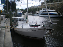
0730: Docked, Nassau Harbour Club & Marina, winds ENE 20-25 gusting to 30kts. It's been a stormy rocky night, even at dock, and the conditions have not improved, so we decide to stay in safe harbour today. Chris hammers out some repairs and maintenance, I get online and use skype to call UAL to change my reservations, delaying my return to 04-06-09. 1800: Ole & Susan invite us over to see their sailboat and have a cocktail. More stories and advice on the cruising life and experiences past, they share with us things that one cannot learn from books and guides. Truly genuine people sharing their lifetime of experiences. Wanting to share something with Ole & Susan, I gather up my pareau gifted to me in Tahiti upon finishing the Hawaiki Nui race in 2007. It marks a special time and place for me, and I'm happy to share it with Ole & Susan, in our exchange of special moments.
Sunday, March 22, 2009 Lat: 25* 03.8N, Long: 077* 15.4W, winds 20-25 kts, COG: 109, seas are choppy.
1000: Depart Nassau Harbour Club & Marina, heading to Highbourne Cay. Forecasted weather to remain stormy for the next four days, but we decide to make a move rather than sit idle. Raging current and winds, it takes two dock masters to help us reverse out of slip #10. Successful, we wave goodbye to Ole & Susan and wish each other well.
1140: We pass Athol Island and Porgee Rocks into deep water. Seas are rough and choppy, motorsailing with one full jib, doing 6.4 kts. It's 4.5 hours to Highbourne Cay and we do a course change to Lat: 25* 02.8N, Long: 077* 13.5W COG: 148, towards the SW point of Highbourne Rocks.
1700: Drop anchor Highbourne Cay Anchorage, Exuma Cays. Lat: 24* 42.9N, Long: 076* 49.8W. We took another beating today, motorsailing in ENE winds 25-30 kts in choppy seas. Even got some wind burn. But racing up behind us were six other sailboats, indicating we were not the only idiots on the move. There's a malestrom of other sailboats and catamarans already anchored as the final vessals squeeze in for the night, one hilariously shouting, "coming through!". Sand bottom, our anchor dragging yet once again. Anchor up, but this time Chris decides to put out a different style anchor...and it holds! Yippee! Iwalani is the drag queen no more. Anchor #1 - The Culprit, anchor #2 - The Successor. Highbourne Cay is privately owned so we cannot go ashore. Fine by me, I'm beat.
Monday, March 23, 2009, Lat: 24* 42.7N, Long: 076* 50.0W, COG: 233
1030: Depart Highbourne Cay, heading out 4.5 nm W to deep water before heading south towards Shroud Cay.
1237: Motorsailing with one full jib, 6.3 kts, mostly cloudy skies with good visibility. Making good time, we pass by Shroud Cay and head to Hawksbill Cay, reportedly one of the most attractive Cays within the Exuma Cays Land and Sea Park. The Park, a designated marine replenishment area and nursery for all the Bahamas, is made up of 15 major Cays and numerous smaller ones encompassing 176 square miles. The capture and or removal of any fish , turtle, crawfish, conch, welk and shells (inhabited or not) is prohibited. The Park starts at Wax Cay Cut in the north and stretches southward some 22 miles to Conch Cut, with an average width of 8 miles. There are no commercial developments within the park, and the few inhabited islands are privately owned. The Park areas are strictly controlled, and the waters are patrolled by Park Wardens.
1440: Anchor on a mooring, Hawksbill Cay, Exuma Cays, Lat: 27* 27.9N, Long: 076* 46.7W. We quickly settle in, rinse off Iwalani and hop into Alaka'i and head to shore. The sand is extremely fine, more so than Bellows in Nalo, and the low lying Cay is filled with prickly brush and razor sharp rocky bases similar to Kona's volcanic plains and ledges. We explore a wide creek at very low tide, then head back before the tide changes. Wading and dragging Alaka'i back into the water at a 1' depth, along comes ANOTHER Barracuda, cruising the shoreline and checking us out, trying to determine if we're suitable prey. Not today buddy.
Tuesday, March 24, 2009, Lat: 24* 27.8N, Long: 076* 46.6W, COG: 160, winds ESE 15-18, seas are choppy, motorsailing with one full jib at 5.5 kts.
1000: Anchor up, release mooring and depart Hawksbill Cay for Little Farmers Cay.1340: Course change, tacking North, Lat: 24* 14.8N, Long: 076* 36.6W. Weather has fouled, winds changed to E 20 kts, getting pushed too far out into the Banks, and being pounded with solid 2' chop.
1445: After much debate considering foul weather, winds and little remaining daylight, we abandon plans for Little Farmers Cay and select an anchorage just north of it, on Great Guana Cay.
1825: Drop anchor, Little Bay, Great Guana Cay, Exuma Cays. Lat: 24* 04.7N, Long: 076* 23.0 W. Winds are HOWLING E 20-25 kts and gusting 30, mostly cloudy skies, good visibility and an excellent anchor hold. It was a long hard day of sailing against the prevailing winds. We were expecting the forecasted northerlies, but instead got strong easterlies. Gotta deal with whatever is handed to you out here. We covered about 35 miles today in foul weather, and my nerves are frazzeled. Feeling dis-com-bob-ulated, this time LISA needs the rum and coke. I once again thank the heavens for Chris, and gladly settle into his arms. Little Bay is a small and picturesque bay with clear blue waters, its' surface rippled by the 30 kts winds. Great Guana Cay is one of the largest Cays in the Bahamas, with a settlement at Black Point, just north of our anchorage.
Wednesday, March 25, 2009, Lat: 24* 04.2N, Long: 076* 23.2W, winds still strong E 15-20, COG: 185, speed 6.0 kts.
0945: Anchor up, we depart Little Bay, heading to Little Farmers Cay just off the south end of Great Guana Cay. We decide to take it easy today wit a shhort and easy sail, well deserved at this point.
1130: Moored at Little Farmers Cay, Lat: 23* 57.8N, Long: 076* 19.1W. Off the southern most tip of Great Guana Cay, Little Farmers Cay is just 2/10's of a mile away, but separated by a very shallow sand bank. We go ashore to visit the famed Ocean Cabin Restaurant, owned and operated by Terry Bain and family. It's a very friendly place where we meet other sailing folk, and exchange introductions. Having lunch and a few beers at Ocean Cabin along with our cruising neighbors, we all participate in a local song about the idyllic life on Little Farmers Cay, which put everyone in a festive island mood.
1500: Hiking the hill that leads to nowhere, we descend and walk the beach towards a massive shipwreck. A rusty heap lying dormant high above the high water mark, we speculate it ran aground after losing its' mooring during a storm or gale. Upon our return to Iwalani, Chris dives to check out the mooring and puts out an additional anchor, just to be safe. Weather should improve over the next two days. Departure tomorrow morning from Little Farmers Cay to Long Island, south of Great Exuma.
HELLO YOU GUYS..THE PICTURES ARE THE GREATEST.
ReplyDeleteDAD HAD SAID SOMETHING ABOUT E-AMIL TO BOAT. THE ONLY THING WE HAVE IS SKYMATE AND BLOG FOR IWALANI. YOU ARE A CAPTIAN, JACK OF ALL TRADES,COCONUT TREE CLIMBER , WOW!!!!!!!SO PROUD OF YOU GUYS. KEEP UPDATES COMING. SO MUCH ENJOY LISA'S COMMENTS. ALL OF US ARE OK. LAST WE HEARD FROM YOU WAS ON 3-26.
LOVE MOM